Sydney: BRT tunnel and trams
December 17, 2012
Sydney is confronted to bus congestion in its Core Business District (CBD):


6,000 bus enter into the Sydney CBD per day, 1000 during the peak hour. Too many bus routes lead to a poorly legible network
Beside a poorly legible network (Sydney has 850 bus routes) [7], the great number of bus routes is also a source of inefficiency : thought that the offering bus-seat capacity could be great, the practical one could be much less on a given corridor (over-supply on some bus routes is not compensating under supply on others)
The European solution
It is a problem many European cities are facing, and in Europe, it is in general the impetuous to switch to LRT – the rational is simple:
- A modern Tram replaces 5 buses
- Associated network consolidation allows a better adjustment of the offer to the demand, as well as a better legibility of it
- A Tram, being electric powered, generate less noise, and pollution
Hence trams improves the livability of the city. Generally, European modern trams are not justified by speed or urban development opportunities, which are very limited in mature cities but mainly by ridership. They operates on trunk lines fed by bus routes:
- Passengers have to transfer
The fact that the transfer from bus to tram, is not compensated by a time gain (like it could be from bus to subway) is one of the main drawback of such an approach. Providing a superior service and experience is a way to compensate for the disagreement. The European solution in Sydney’s CBD could be the vision proposed by Gehl Architects [2]:

Pedestrian George Street with LRT, in a typically European arrangement – credit picture (2)
The Australian approach
Australia is land of the finest BRTs. Tunnel a BRT is a solution, natural enough in Sydney, to be considered, in despite of its price tag; $2 Billions, for a ~2 km tunnel. The rational is simple:
- A BRT can avoid a transfer
The debate


BRT vs LRT, the context of the debate - Left: Bus volumes entering the Sydney City Centre during the two hour morning peak - Right: proposed BRT and LRT alignment and cost. The full LRT is 12 km long with implementation cost estimated at $1.6B
You could expect the government agencies, ministries and other actors to debate on facts, and not on opinions to lobby one system over another:
reading the different reports [3][4][5] will prove you wrong.
Below is how the debate has occurred between two New South Wales (NSW) government outlets, Transport NSW, favoring the LRT, and Infrastructure NSW (InNSW), an “independent agency”, supposed to not base recommendation on politic allegiance, favoring the BRT:
InNSW estimates the current demand at 9000 pphpd in the corridor [5]. The different system are assumed as below by the different actors:
| System | InNSW [5] | Transport NSW [3] | Certu [6] |
| BRT Capacity | 20,000 | 3,500 | |
| LRT Capacity [9] | 9,000 | 12,000 | 6,000 |
| LRT Frequency | 2mn | 2mn | 3mn |
The numbers provided by Certu (a French agency), are for reference. They are considering optimal surface operation conditions (signal preemption possible, perfect interval maintained) signaling the typical area of relevance for a given technology. Thought the numbers advanced by the Australian authorities are theoretically possible, they most probably supposes a compromise on the level of service:

High capacity BRT, like the one pictured in Brisbane come at a cost – credit photo (1)
The InNSW report contains lot of fear mongering on LRTs, but what is noticeable in the case of the both approaches, is that none quantifies travel time, neither expected operating cost, not even speaking of a cost/benefit ratio.
More importantly, beside removing bus of the surface, the BRT tunnel tries to address a problem different from the LRT: the former addresses regional access-and so doing tend to largely duplicate an existing rail corridor- while the later addresses the more local access into the CBD. One will find some more detail, especially question about the BRT approach in [8]
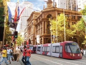
The urban approach: George Street
As suggested before, the tram choice over a tunnel BRT is not only a transportation choice, it is an urbanistic one too: George street is a 2.5km long street, it is the major Sydney spine. Jan Gehl compares its potential to the one mile long Barcelona’s las Ramblas [2]:
- Both are bounded, by the sea on one side, and by a major commuter railway station on the other
- Both are of similar with, 22 to 30m for George street
The Cost of the different approaches for George street:
| BRT Tunnel [5] | Surface LRT [3] |
| $2B | $500M |
InNSW suggested that George street -20 to 30m width- is not wide enough to accommodate both a tram and pedestrians, and explains that segregation of transport and pedestrian activities, or aggressive pedestrianization, is a better objective [5] (There is very few street of this wide successfully fully pedestrianized [10]). the Bus BRT is considered as a rapid transit with 2 underground stations [5].

George Street cross-section – as proposed by Gehl architects – credit (2)
Jan Gehl touted the concept of overlap use, with trams sharing the urban space with pedestrians, supporting thriving activities on the rather wide George street, and the neighboring alleys and lanes. In fact Transport for NSW states in [3]:
International experience indicates that the pedestrianization of George street without activation by light rail could reduce safety and accessibility, leading to a decline in retail activity.
The surface tram option is envisioned with a stop every 350m, so the tram is considered as a people mover. Evolving in a shared space, its average speed will not be much better than 10km/h on George street – Rest of the alignment is in a more “suburban” environment, so average speed outside the CBD should be more competitive with existing option
Some questions
At the end the LRT has been chosen over the BRT. Nevertheless, considering the expected passenger volume, one could still question this choice:
Shared spaces work well when traffic is light :
- Crossing the street is unimpeded by traffic (that is one advantage of fewer trains over more buses)
In the George street case, the demand suggests a train every mn, so starting to create a “wall” of trains:
Too heavy LRT traffic can compromise the “sharing space” concept
But what could be of more concern, is that the system could be under-sized. The considered 9,000 pphpd requirement suggests that the debate should not have been a BRT versus trams one, but eventually trams versus a heavier rail mode, including a grade separated LRT – that is the Ottawa direction – or extension of the Sydney Cityrail (a S-bahn or RER equivalent). The later is fortunately on the menu [7], and hopefully will go in a direction to reduce the pressure on the tram.
Lessons for Vancouver.
Th Sydney LRT choice has generated some interest in Vancouver here and there : The Sydney choice is done to address problems very different of the ones faced either by Vancouver or Surrey. Still, the underlying motivation, for the heavy transit investment, is mainly to address existing demand. It also shows you are better to understand what objective you are trying to pursue, before embarking into a technology debate, which can lead on exaggerated and misleading claims.
If there is one lesson to be directly learned for Vancouver, it is the idea that [3]:
separating pedestrians and transport is contrary to good planning practice and international experience, which shows transport and pedestrians should be integrated to support thriving cities

Transit at Sydney Town Hall
Integrating transit into pedestrian oriented streets, is also the only way to have an extensive and still successful pedestrian friendly street network. In other word, let transit work, is the first and probably most important step toward bold pedestrianization scheme: An important lesson we could learn more especially fromWellington, NZ.
All $ figure in Asutralian $
[1] flickr user SHOROC
[2] George street Urban design study, Gehl Architects for City of Sydney, January 2012
[3] Sydney Light rail’s future, Transport for NSW, December 2012
[4] Metro Transport Sydney’s position on LRT
[5] First things first, Infra NSW, October 2012.
[6] Tramway et Bus à Haut Niveau de Service (BHNS) en France : domaines de pertinence en zone urbaine from Transport/Environnement/Circulation (TEC) n° 203, September 209.
[7] Transportation Master Plan, Transport for NSW, December 2012
[8] transportsydney.wordpress.com blog.
[9] That is considering a 45m long train. Fine grained Sydney downtown grid doesn’t allow for much longer trains on George street without hindering access to lateral streets
[10] New York City’s Broadway at ~80 feet wide is one example, but the pedestrianized block around Times Square see a traffic of 350,000 pedestrians/day – a uncommonly high volume.
 The name "Voony" comes from the name of the author's family cat. The author is the guy in the picture. This blog revolves mainly around transportation and urban issues in the Vancouver area.
December 17, 2012 at 9:34 pm
Seriously? I have been in pedestrian streets all around the world that do not have surface transit. Clearly it is not required for a successful pedestrian street.
December 17, 2012 at 10:50 pm
Richard:
(1) I quote Transport for NSW (ref [3]) which in turn, based its recommendation on Jan Gehl input (ref [2]).
(2) George street is 20m minimum wide: it is very unusual to have such wide street pedestrian only – usually, there is not enough pedestrian volume, to “fill” the space, without artificially reducing it.
If you have counter-example, I am willing to take it- but I am pretty sure they will pertain to very specific situation, like Broadway at NY times square.
(3) and more important, it is not a single street we are talking about, it is a whole streets network which aim to be pedestrianized (and I am pretty sure we have this ambition for Vancouver too, isn’it?)…and still the streets/areas in the middle of a pedestrian network need to be as accessible as the ones on the edge to make the scheme a success.
That is the reason why I say
“Integrating transit into pedestrian oriented streets, is also the only way to have an extensive and still successful pedestrian friendly streets network”
December 18, 2012 at 1:47 am
Pedestrianized streets as wide as George Street are common in German cities. Examples are in Frankfurt, Cologne, Munich, and Duisburg off the top of my head.
Right now these streets are filled with gluhwein and lager and currywurst and bad renditions of 80s American pop music.
December 18, 2012 at 11:25 pm
I guess you think of street such as Zeil in Frankfurt or
Kaufinger strasse in Munich.
You will have hopefully noticed their overall size (width, and length), the wealth of transit options feeding them directly, (in some case the station entrance are directly in the middle of the street- in the linked example, the bus on Marienplatz…) : Pretty much the point I made.
In China, they have also very large pedestrian streets, starting by Nanjing road in Shanghai…but again it is fed directly by 2 subway lines, one of them carrying 1.4M rider/day (wiki), busses…
December 18, 2012 at 9:48 pm
Because city names are too vauge, here are the German strees. Also, note that these are just the wider streets in a larger network of pedestrianized streets. Most of these wide streets have the u-bahn or s-bahn under them.
Frankfurt has the 30-metre-wide Zeil: http://en.wikipedia.org/wiki/Zeil
Cologne’s 11-m cardo, Hohe Strasse, continues into its 17-metre-wide decamanus, Schildergasse. These don’t quite make the 20-metre cutoff.
http://en.wikipedia.org/wiki/Hohe_Stra%C3%9Fe
http://en.wikipedia.org/wiki/Schildergasse
Munich’s 20-metre-wide Kaufingerstrasse opens to the 30-metre-wide Neuhauser Strasse.
http://de.wikipedia.org/wiki/Kaufingerstra%C3%9Fe
Duisburg has the 30-metre-wide Konigstrasse: http://de.wikipedia.org/wiki/K%C3%B6nigstra%C3%9Fe_%28Duisburg%29
December 19, 2012 at 12:07 am
didn’t notice this comment before …note that 20meters is the narrowest part of George street – However Sydney has also Martin Place mall tied to George street. – and which configuration, length, transit anchor, is similar to the German examples you give: Those street have their own specificity as you have noticed: Strong transit anchor giving access to a larger network of a more “usual” pedestrian street width…
PS: Germans have also good music
December 19, 2012 at 12:11 am
Kettwiger Strasse in nearby Essen is an example of a wide pedestrian street, part of a larger pedestrianized area, where the transit runs parallel a block or more away.
December 20, 2012 at 11:16 pm
Interesting case, especially the significant square (KennedyPlatz):
at least one example to support no transit on Robson?
It looks in fact the transit spines form a triangle (see map– Kettwiger Strasse starting from the major transit point of it: the railway station.
Also, North of the the base of the transit triangle, is what seems a major University (students can be an important contributor to urban life)
The square and Kettwiger Strasse seems to be the barycenter of that.
The pattern could look in some aspect similar to the Sydney one (CityRail surrounding George Street, with the main railway station at one end, the Ferry at the other)…but George street is much longer (2.5km), and more important:
Kettwiger sounds closer to 15m wide, than 20-30 meter wide.
May be, that is the primary reason why the tram elected to not run on it in the first place?
A tram running down Kettwiger could use 40% of the street wide, when it could use only 25% (average) of George street.
December 19, 2012 at 11:40 pm
The distance between transit stops on the Zeil in Frankfurt or Kaufingerstrasse in Munich or Konigstrasse in Duisburg is more than 500 m.
The distance between transit anchors at Granville/Georgia and Robson/Burrard along Granville and Robson is about 500 m.
Vancouver’s retail is concentrated on relatively few streets instead of spread throughout each district. In many other cities, the centre has many busy small streets with retail that are not useful to transit or traffic. There is less conflict in pedestrianizing these small streets. Here, pedestrianization is more difficult because the busy streets with retail are also the wider streets with transit.
December 20, 2012 at 11:30 pm
Not sure that Robson/Burrard can be called a transit anchor: Beside bus 2/22 on Burrard and 5 on Robson, it is pretty much it – other routes are peak only, save for the 44 but still no service after 8pm or on WE.
Also in the above German cases, the street link directly one anchor to the other…no turn (traffic dispersion).
For the rest, I agree…That is the reason I believe we should be more looking at streets like Zurch’s Bahnofstrass
and look at what can be done with a Trolley (see this post) for street/square like Robson
January 21, 2013 at 8:39 am
on private rights-of-way or sometimes in streets. Light rail is a step below rapid transit, which is fully grade-separated…… Click the link for more information.
February 24, 2014 at 12:06 am
[…] Specific bus route could be overloaded, but in some key downtown corridors (mainly Hasting and Granville), there is an over-all over supply of bus-seat (over-supply on some bus routes is not compensating under supply on others)- a typical problem of urban core we have already encountered, in a more acute form, in Sydney, Australia […]
January 8, 2015 at 1:05 am
[…] said, Sydney is building a LRT supposed to accomodate 9,000pphpd on its downtown segment, […]