The Downtown Vancouver Bus Service vision in 1975
July 2, 2013
At a time when “both TransLink and the City of Vancouver are aiming to establish a common vision for bus service in downtown Vancouver“, it is still interesting to have a look at what has been done in past in that respect
In 1975, the Bureau of Transit Services, then depending from the Minister of municipal affairs prepared a transit service plan to complement the City land plan [1]:

1975 proposal for the Vancouver Downtown transit Plan, extract from [1]
This plan is important in many aspects, and mainly the adopted methodology
It lays down the general picture in which a downtown plan can take shape
Thought not in service in 1975, the West Coast Express concept were already discussed, and the terminals and vessels, for the seabus, were under construction. The skytrain was still a quite distant concept [2], but the LRT discussed in the plan is clearly considered as a pre-metro, aimed to be underground in the Core Business district.
But More importantly,
It lays down 7 principles guiding the plan
Those principle are subdivized into 3 common service characteristics:
- Direct Routing
- Minimize unecessary transfers
- Minimal walking distance to final destinations
(1) Don’t divert routes to serve specific needs: Diversion means a less attractive service for most of the travellers
(2) Use secondary services connecting to main ones, to serve “out of the way” area (rather than divert main routes)
(3) Use the downtown grid for “random schedule” transfers

(4) Go Straight thru the “center of gravity” of an area, and not its periphery, which increases the total walking distance by half.
(5) Transit and pedestrians: the concept of pedestrianization and transit must not be treated independently.
The study cites Jane Jacobs [3] to support the idea of bringing together the transit network with the pedestrian area [6]
(6) Prefer two way operations over one way, since it offers the maximum coverage
(7) Prefer nearside bus stop over farside, sinec it allows the passengers to alight before have to wait at a traffic light.
Many, if not all, of this principles are what Jarret Walker calls the geometry of Transit, and that is the reason why they are still as valid in 2013 as they were in 1975:
- Principle (7): Thought some cities like Montreal and Toronto, have bus stopa on the nearside, most of the cities adopt a farside model, since it usually allows a better general traffic output, and modern LRT/trams use also farside bus stops, since it allows a more efficient signal preemption
- Principle (1), (4) and (6): They are very strong transit geometry principles which have justified the conversion of Manners Mall in Wellington New Zealand, from a pedestrian only street to a transit mall.
- Principle (4) and (5) are why transit needs to be considered as part of the urban fabric
Some comments on the DT plan
The geometry of transit largely comfort the relevance of the historic streetcar grid:
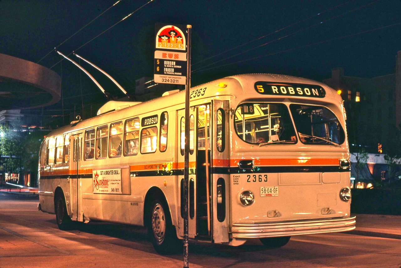
Robson bus 5 ( Ex-Saskatoon Brill trolley 2363), at Robson square, in May 1980. Note the “Shoppers Free” Bus sign – Photo, courtesy from Angus McIntyre
- The choice of the streets is guided by principle (4)
- The streetcar service along Hornby, was expected to use the Arbutus line outside the DT core: the routing thru Hornby plan is consistent with the 1972 Erickson plan developped for the court house complex.
- The Robson square is envisioned to be a pedestrian oriented area, serviced by transit in full accordance with principle (4), and the Arthur Erickson’s vision for Robson square:
-
The only traffic through the square will be inner city buses, linking the West and and False Creek. Since buses function as people movers, they are seen as a compliment or enhancement to the pedestrian activity of the civic square […]
- At the time of drafting the plan the Robson bus was using the couplet of one way streets Smythe/Robson: a two way service along Robson is clearly the privilegied choice.
-
The advent of the Canada line kind of fullfill this vision.
The underlying philosophy leading to the plan, articulating pedestrian areas around transit, and not the reverse, illustrates the dramatic shift of the current Vancouver council approach, which dismiss the transit geometry, as illustrates the Robson bus circling the square to serve a “specific need”.
At the end a transit service is envisioned on Nelson to complement the planned development of the westend, as well as a pheripheral line, to serve the “social and recreational” place on the pheriphery of downtown:
Remarkably, they are echoing recurring wishes for Transit in downtown, but the plan warms that “…there really is not much to be gained in professing support for programmes to get more people to use public transit without commitment to actions to give transit priority use of streets in Downtown Vancouver and in other urban centres in the metropolitan area.”
Alas, the current Vancouver council policies could not be farther apart of this commitment to transit.
One can also consult [5] for a different coverage of [1]
[1] Draft memorandum on transit service planning to complement downtown peninsula plans of the City of Vancouver, Bureau of Transit Services, BC Minister of Municipal affairs, Sept 19, 1975. (13.6MB file)
[2] the underlying concept had been drafted by Harry Rankin by 1970, see The Case for Rapid Transit…in 1970
[3] The Death and Life of Great American Cities, Jane Jacobs, Random House, New York, 1961
[4] 51-61-71 Project, block 71 Schematics, Arthur Erickson Architects, 1974
[5] Vancouver’s 1975 downtown transit plan, John Calimenete, April 7, 2010
[6] This view is echoed by Jan Gehl, among others, providing rational for Transit on Sydney’s George Street.
 The name "Voony" comes from the name of the author's family cat. The author is the guy in the picture. This blog revolves mainly around transportation and urban issues in the Vancouver area.
July 2, 2013 at 1:37 am
Hastings west of Main carried 109 buses per hour in 1975.
I’m just… 109 buses per hour. 8400+ pphpd. I just don’t even.
Other details here are pretty damn interesting. SeaBus originally planned at 8 minutes travel time (that’s, what, half the current!?).
July 2, 2013 at 11:47 am
Gord – if I remember correctly, downtown bus service was free in 1977 when I first moved to Vancouver. Sort of shoppers transit. It was ended shortly thereafter.
I believe our sister cities of downtown Seattle and downtown Portland still have this free service. Certianly they used to. I think a return to free downtown bus (not SkyTrain) service would help also address Councillor Meggs recent call for free transit for the homeless, at least the great bulk of whom reside in Vancouver where the majortiy of social services, housing and possible jobs are still located.
Can you or anyone else confirm this “fact” to complement this interesting posting?
July 2, 2013 at 8:17 pm
The fareless downtown areas in Seattle and Portland were removed in the last couple years.
Since 1975, rapid transit has eliminated almost all of the constraints on the design of the downtown network that resulted from the need to accommodate regional and even some local buses. These constraints were considerable.
The capacity provided by adjacent parallel streets is no longer needed, specifically on Hastings and the Powell/Cordova couplet. There aren’t enough buses to justify the separation, and it makes for worse transit in the corridor.
The connection to far-faster rapid transit service to downtown has eliminated any special need for the Main, Fraser, Kingsway, Commercial/Victoria, and Renfrew buses to go downtown. Nearly everyone transfers to SkyTrain.
The one big thing that can improve transit downtown is separating buses from traffic. Fewer but more frequent routes can share separated lanes and stops downtown, even when they have dissimilar stopping patterns outside the downtown.
Rapid transit has imposed new constraints on the design of the downtown network, though they aren’t so onerous. Basically, the buses have to connect to the stations as quickly and as directly as possible. Whether the Robson bus goes through Robson Square or straight to Burrard Station makes little to no difference to trip times connecting to the Expo and Canada Lines. The debate over buses through Robson Square should really be about whether it makes the square better.
July 2, 2013 at 11:28 pm
To answer to Daryl, Franck Ducote (here it is “Voon”, “not Gord” 😉 ) and Mike:
(1) on the volume of buses: yes it was fairly impressive (it was 109 buses/hr one way!)…this reminds us, that the traditional justification for trams/streetcar in Europe, or in Sydney, is to decongest streets from buses.
(2) Yes, it was a fare free zone: the reason I have selected this picture of the bus 5, is that it highlights the “Shoppers Free” Bus sign.
As an advocate for “road pricing”, I generally disagree on “free transit” (the same logic apply whatever the transportation mode), – the fact that homeless could perfectly squat the buses can also be considered as a deterrent to transit usage…but if a juridiction want to provide free transit to some of its constituents, it is free to buy bulk fares (it is in essence what is happening with the student pass), and Vancouver can do if it want to…
(3) the Robson “Shoppers Free” Bus sign is also remainding me, that a Study on Sydney concluded
“International experience indicates that the pedestrianization of George street without activation by light rail could reduce safety and accessibility, leading to a decline in retail activity.”:
I generally agree with Mike, but could have to quibble on Robson square: I don’t think that “The debate over buses through Robson Square should really be about whether it makes the square better”, but if it has the potential to make the whole down town (and Vancouver) a better place or not…
That can be either aggressive pedestrianiation of a short strip, or a greater pedestrianization scheme…which then raises the question of accessibility and activation (that is the dilemna of european cities, a dilemna also encountered in Wellington)
July 3, 2013 at 7:22 am
Vancouver never had a free downtown zone as Seattle did, but for a number of years starting in the mid-1960s there was the DOWNTOWNER pass, sold on buses in the downtown core only for 30 cents, when the fare was 20 cents. This permitted the pass holder to ride downtown buses freely and shop between 9:30 and 3:00, and it covered your ride home as well. It included all of the West End to Stanley Park. Many West End residents would buy the DOWNTOWNER in the morning for their downtown trip, use it to go home, say at noon, and leave it at the mailbox of their apartment building for another resident to use. The pass was not valid outside this area, so it the passenger had to transfer, say at Broadway, he/she could exchange the DOWNTOWNER for a transfer. The Shopper’s Free Bus essentially replaced the DOWNTOWNER, and used Brill diesel buses painted in a paint scheme to mimic the old B.C. Electric observation cars. There were some interesting innovative ideas floating around in those days. Keep in mind this was also at a time when everybody put a fare in the fare box, as there were no monthly passes. While fare evasion was virtually nil, people would still try and fudge their transfers.
July 3, 2013 at 10:36 pm
Angus sent me this photo of transfers and punch, showcasing the DOWNTOWNER pass

November 8, 2013 at 11:28 am
[…] I have mentioned that those principles were already stated in the 1975 downtown bus review, ( see here for a summary and the full copy. I should have mentioned Jarret Walker’s ‘Geometry of […]
March 4, 2014 at 1:23 am
[…] The Downtown Vancouver Bus Service vision in 1975 […]
April 18, 2016 at 9:34 pm
[…] upon which a good pedestrianisation policy can be built, are well-known, and were recognized in the 1975 Vancouver downtown bus review . The most important is to have direct routes going straight to the center of gravity of an area to […]